
Zion & Bryce Canyon: Utah’s Other National Parks
Southern Utah holds a genuinely remarkable concentration of national parks within a few hours’ drive of each other, and Zion and Bryce Canyon, roughly two hours apart, offer two of the most distinct landscapes in the entire national park system. This guide compares the two directly, checked against real research into each park’s defining features, hikes, and best season, with a look at the shared geology that shaped both in such dramatically different ways.
What makes pairing these two parks genuinely worthwhile, beyond their short driving distance apart, is how completely different they feel despite both being carved from the same broader Colorado Plateau region. Zion’s defining feature is verticality, towering sandstone walls rising as much as 2,000 feet above a narrow canyon floor, while Bryce Canyon inverts that experience entirely, its main attraction viewed from above, looking down into a natural amphitheater packed with thousands of narrow rock spires. Visiting both back to back genuinely showcases the range of landscapes this single region of the American Southwest can produce.
Both parks also carry genuinely significant Indigenous history predating their designation as protected land. The Southern Paiute people have inhabited the region around both Zion and Bryce Canyon for centuries, and Bryce Canyon’s own name in Paiute oral tradition, loosely translating to “red rocks standing like men in a bowl-shaped canyon,” reflects a genuine cultural relationship with the hoodoo landscape that long predates the park’s more recent, colonially-derived name, taken from Ebenezer Bryce, a Mormon settler who homesteaded near the canyon in the 1870s and reportedly once remarked that it was “a hell of a place to lose a cow.” Keeping that deeper history in mind while exploring either park adds a genuine layer of context often missing from a purely scenic visit.
Zion National Park
Bryce Canyon National Park
How These Landscapes Formed
Zion vs. Bryce Canyon
Best Time to Visit Both Parks
Planning a Trip Between Both Parks
FAQ
Zion National Park
Genuinely defined by verticality, Zion’s massive sandstone walls and narrow canyon floor create a hiking experience unlike almost anywhere else in the American national park system, one built around moving directly through the landscape rather than simply viewing it from a distance.
The Narrows
Zion’s single most distinctive hike involves genuinely wading directly through the Virgin River, since for a significant stretch of the route, the canyon walls close in so tightly that the riverbed itself becomes the only trail. Water levels and depth vary by season, and renting a walking stick and water shoes at outfitters near the park entrance is a genuinely common, worthwhile practice, given how much of the hike involves navigating a slippery, uneven riverbed. The canyon walls rise up to 2,000 feet on either side at points, reducing the sky above to a narrow ribbon of light, an experience genuinely unlike any other maintained trail in the park system. A top-down version of the hike, starting from Chamberlain’s Ranch and running roughly 16 miles, offers a genuinely more serious backcountry alternative to the popular, shorter bottom-up route most day hikers attempt.
Temple of Sinawava, northern end of Zion Canyon. Park entry fee; shuttle required during peak season. Best in summer, when water levels are typically lower and warmer, avoiding the colder, higher-flow conditions of spring snowmelt.
Angels Landing
A genuinely exhilarating, and genuinely dangerous, hike climbing to a narrow rock fin, its final half-mile navigated via a chained section of trail with sheer drop-offs on both sides. The National Park Service now requires a permit, obtained through a lottery system, to hike the final chained section, a response to the trail’s popularity and its real safety risks, several fatalities have occurred here over the years, making the permit system a genuinely necessary management tool rather than an arbitrary restriction. The trail’s name, according to local lore, originated with a early park visitor who reportedly remarked that only an angel could land on such a precarious summit, a story that’s become part of the trail’s own legend regardless of its precise historical accuracy.
The Grotto, Zion Canyon. Permit required for the final section, obtained via lottery. Best starting early morning, both for cooler temperatures and to secure a manageable pace on the trail’s narrower sections.
Bryce Canyon National Park
Despite its name, Bryce Canyon isn’t technically a canyon at all, but a series of natural amphitheaters carved into the edge of a high plateau, and the effect is genuinely unlike anything else in the American Southwest, a landscape that looks almost sculpted by hand rather than shaped by natural erosion alone.
Bryce Amphitheater
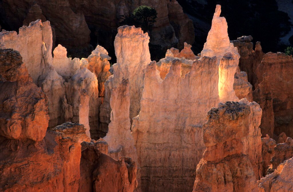
Home to the largest concentration of hoodoos, tall, thin rock spires shaped by frost weathering and erosion, found anywhere in the world, Bryce Amphitheater’s orange and pink formations are best appreciated first from rim-top viewpoints like Sunrise Point and Sunset Point, both offering sweeping views without requiring a hike, before descending into the amphitheater itself via trails like the Navajo Loop or Queens Garden Trail for a genuinely different, closer perspective among the spires themselves. Despite its name, Bryce Canyon isn’t a true canyon carved by a river, it’s technically a series of amphitheaters eroded into the eastern edge of the Paunsaugunt Plateau, a geological distinction that genuinely explains why the park’s landscape looks so different from a conventional river canyon.
Bryce Amphitheater, along the park’s main rim road. Park entry fee. Best at sunrise, when the hoodoos’ orange coloring is at its most vivid against the early light.
Thor’s Hammer & Notable Formations
Among Bryce’s thousands of individual hoodoos, a handful have earned genuine individual recognition for their distinctive shapes, Thor’s Hammer, its balanced, top-heavy silhouette visible along the Navajo Loop Trail, remains one of the most photographed single formations in the entire park, a genuinely striking example of just how precisely erosion has sculpted this landscape over millennia. The park’s Wall Street section of the Navajo Loop Trail, a genuinely narrow, switchback-heavy descent between towering rock walls, offers a dramatically different hiking experience from the open rim views above, and it remains one of the most popular routes into the amphitheater for exactly that contrast.
Navajo Loop Trail, Bryce Amphitheater. Included with park entry. Best combined with the broader Navajo Loop or Queens Garden Trail, since Thor’s Hammer sits directly along the route.

Emerald Pools & The Watchman
For visitors seeking a gentler alternative to the Narrows or Angels Landing, Zion’s Emerald Pools Trail offers a genuinely family-friendly route past a series of small waterfalls and pools, with three distinct sections (Lower, Middle, and Upper) allowing hikers to choose their own difficulty level depending on time and energy. The Watchman, a distinctive peak visible from the park’s southern entrance, has become one of Zion’s most photographed formations in its own right, particularly at sunset, when its western face catches the day’s last light in a genuinely dramatic wash of color.
Zion Canyon Visitor Center area. Included with park entry. Best in the late afternoon for The Watchman viewpoint, when the peak’s western face is fully illuminated.
Fairyland & Inspiration Point
Beyond the main Bryce Amphitheater viewpoints, Fairyland Point offers a genuinely quieter, less crowded overlook with its own distinct cluster of hoodoos, connected to the main amphitheater via the longer Fairyland Loop Trail for hikers wanting a more solitary route through the park. Inspiration Point, meanwhile, offers what many consider the single best comprehensive view of the entire amphitheater, its elevated position revealing the full scale and density of the hoodoo formations below in a way lower viewpoints simply can’t match, a view genuinely worth the modest extra walk from the more crowded main pullouts.
Fairyland Point (northern end) and Inspiration Point (main amphitheater), Bryce Canyon. Included with park entry. Best visiting Inspiration Point at sunrise, when the full amphitheater view is at its most dramatic.
How These Landscapes Formed
Both parks share a genuinely deep geological connection despite their dramatically different appearances today, both sit within the same broader Colorado Plateau region, and both were shaped by the same fundamental forces of water and erosion acting on ancient sedimentary rock, just at different points along a shared geological timeline sometimes called the Grand Staircase. Zion’s Navajo Sandstone, formed from ancient sand dunes roughly 200 million years ago, sits at the bottom of that staircase, while Bryce Canyon’s Claron Formation, younger and softer limestone deposited in an ancient lakebed roughly 30 to 50 million years ago, sits higher up the sequence, explaining why the two parks, despite their proximity, expose such different rock types and erosion patterns.
Bryce’s hoodoos specifically form through a freeze-thaw cycle unique to its elevation, water seeping into rock cracks during the day and freezing at night, gradually widening those cracks over centuries until narrow spires remain standing where a solid cliff face once stood. Bryce Canyon experiences roughly 200 of these freeze-thaw cycles annually, a genuinely relentless process that continues actively reshaping the amphitheater today, meaning the landscape visitors see now is subtly, continuously different from what previous generations of visitors witnessed. Zion’s canyon, by contrast, was carved primarily by the ongoing, more conventional erosive power of the Virgin River, a process that continues today and genuinely means the canyon is still, technically, being formed.
Zion vs. Bryce Canyon
| Category | Zion | Bryce Canyon |
|---|---|---|
| Hiking style | Canyon floor, wading rivers | Rim-top viewpoints, descent trails |
| Elevation | Lower, ~4,000 ft canyon floor | Higher, ~8,000 ft rim, cooler climate |
| Crowds | Genuinely very busy, shuttle required | Busy but generally more manageable |
| Best season | Spring through fall | Late spring through early fall |
The two parks genuinely reward different kinds of travelers, or the same traveler on different days of a shared trip. Zion suits hikers who want a genuinely immersive, physical experience, wading through water, navigating narrow canyon walls, and, for those willing to secure a permit, a legitimately thrilling exposed trail. Bryce Canyon rewards a more contemplative pace, its best views achievable from an easy rim walk, with the option to descend further for hikers who want a closer look at the hoodoos rather than just an overlook. Photography also genuinely favors different times of day at each park, Zion’s deep, narrow canyon means direct sunlight only reaches the canyon floor for a limited window each day, while Bryce’s open rim and eastward-facing amphitheater make sunrise genuinely the single best time to visit, when the low light sets the orange hoodoos glowing.
Best Time to Visit Both Parks
Spring and fall offer the most comfortable temperatures for both parks, avoiding Zion’s genuine summer heat, which can push canyon floor temperatures into the triple digits, uncomfortable and potentially dangerous for a full day of hiking, especially in the Narrows where sustained sun exposure compounds the heat. Bryce Canyon’s considerably higher elevation, roughly 8,000 feet at the rim, keeps it noticeably cooler than Zion year-round, and snow can linger into late spring or arrive again as early as October, a genuinely important consideration for anyone planning trail access around a specific date.
Summer remains the most popular season for both parks despite Zion’s heat, since it aligns with school vacation schedules, and the Narrows specifically becomes most hikeable once spring runoff has passed and water levels drop to a manageable, warmer flow, typically from June through September in most years. Winter transforms Bryce Canyon into a genuinely striking, snow-dusted version of its already otherworldly hoodoo landscape, snow contrasting beautifully against the orange rock, while Zion’s canyon floor remains accessible, if considerably colder and quieter than its peak season crowds, though the Narrows hike itself becomes genuinely more demanding and less advisable during the coldest winter months due to icy water and reduced daylight.
Planning a Trip Between Both Parks
The roughly two-hour drive between Zion and Bryce Canyon, largely along scenic Highway 9 and Highway 12, is genuinely worth treating as part of the trip rather than simply a transit segment, the route passes through Red Canyon, a smaller but still genuinely striking preview of Bryce’s hoodoo formations, along with several worthwhile overlooks easy to miss if driving straight through without stops. Both parks operate shuttle systems during peak season, Zion’s shuttle is mandatory for most of the year within the main canyon, while Bryce’s remains optional but genuinely recommended given limited parking at the most popular viewpoints. Booking lodging or campsites well in advance matters for both parks, particularly for anything inside Zion itself, where demand regularly outpaces the limited number of available rooms during peak summer and fall weekends.
If this guide helped you plan your Zion or Bryce Canyon trip, check out more travel videos from Worldly Traveler.
Whichever park anchors your trip, or if you’re fortunate enough to visit both in a single southern Utah itinerary, the real value in pairing Zion and Bryce Canyon lies in the contrast itself. Few regions on Earth let you wade through a river canyon in the morning and stand above a field of orange rock spires by evening, all within a single day’s drive. That range, from Zion’s claustrophobic, towering walls to Bryce’s open, otherworldly amphitheater, genuinely captures just how varied the American Southwest’s landscape can be within a remarkably compact stretch of southern Utah.
Frequently Asked Questions
Should I visit Zion or Bryce Canyon?
It genuinely depends on your priorities and the kind of hiking experience you want. Zion offers dramatic canyon hiking, including wading through a river in the Narrows, while Bryce Canyon delivers a genuinely otherworldly landscape of orange hoodoo spires best explored via rim-top viewpoints and gentler trails.
What are hoodoos?
Hoodoos are tall, thin rock spires formed by frost weathering and erosion, and Bryce Canyon holds the largest concentration of them anywhere in the world, thousands of orange and pink spires packed into a single natural amphitheater.
What is the Narrows in Zion National Park?
The Narrows is a slot canyon hike along the Virgin River where, for much of the route, the canyon walls close in so tightly that hikers wade directly through the river itself, genuinely one of the most unique and memorable hikes in the entire national park system.
How many days do you need for Zion and Bryce Canyon?
5-7 days allows a well-paced trip covering both parks, given their roughly 2-hour driving distance apart along a genuinely scenic route. A shorter 3-4 day trip can cover the essential highlights of each.
What is the best time of year to visit Zion and Bryce Canyon?
Spring and fall offer the most comfortable temperatures for both parks, while summer brings intense heat to Zion’s lower canyon and Bryce Canyon’s higher elevation keeps it noticeably cooler, even snowy, well into spring most years.