
The Golden Circle — Þingvellir, Geysir, and Gullfoss — captures nearly all of the first-day itinerary time and search volume for visitors to Iceland, and it’s a genuinely worthwhile loop for a short first trip. But it covers barely a fraction of the country, and Iceland’s full Ring Road (Route 1) traces a 1,300-kilometer loop around the entire island, passing through dramatically different landscapes that most short-trip visitors never see. This guide covers what’s worth the extra driving time once you’re ready to go beyond the Golden Circle, organized by leg of the drive.
None of this means the Golden Circle isn’t worth doing at all. It’s an argument for treating it as the first stop on a longer loop rather than the entire trip, since the full Ring Road opens up canyons, fjords, waterfalls, and entire regions that see a fraction of the Golden Circle’s visitor numbers.
South Coast Beyond Skógafoss
The Southeast and Vatnajökull
East Fjords
North Iceland
Snæfellsnes Peninsula
The Westfjords
Ring Road Logistics
Best Time of Year
Practical Driving Tips
Where to Base Yourself
FAQ
South Coast Beyond Skógafoss
The South Coast is Iceland’s most-visited region outside the Golden Circle, but a handful of spots stay genuinely quiet.
1. Fjaðrárgljúfur Canyon
A dramatic, sharply winding canyon with mossy, near-vertical walls carved over thousands of years by glacial meltwater, Fjaðrárgljúfur offers a genuinely different landscape from the coast’s famous waterfalls, and its viewing platforms require only a short, easy walk from the parking area. The canyon gained a burst of international attention after appearing in a music video several years ago, which briefly strained its trails enough that Iceland temporarily closed sections for restoration, a reminder of how quickly a genuine hidden gem can change character.
Near Kirkjubæjarklaustur, South Coast. Free. Best in the morning for softer light and fewer visitors.
2. Dyrhólaey
A dramatic promontory with a natural rock arch large enough for small boats to pass through, Dyrhólaey offers sweeping views over the South Coast’s black-sand beaches and, in season, nesting puffins along its dramatic cliffs, all from a vantage point quieter than the more crowded Reynisfjara beach nearby.
Near Vík, South Coast. Free. Best in early summer for puffin viewing; check current access rules during nesting season.
3. Reynisfjara’s Quieter Basalt Columns
While Reynisfjara’s main viewing area draws large crowds for its dramatic black sand and sea stacks, walking further along the beach away from the main parking area reveals the same striking hexagonal basalt column formations with considerably fewer people in the frame.
Reynisfjara, near Vík. Free. Best combined with a Dyrhólaey visit given the short distance between the two sites.
The Southeast and Vatnajökull
Home to Europe’s largest glacier by volume, this stretch of coast offers some of Iceland’s most dramatic scenery.
4. Diamond Beach’s Quieter Side
Jökulsárlón’s glacier lagoon draws large crowds to photograph icebergs washing up on the black sand nearby, but walking further along Diamond Beach away from the main viewing area reveals the same ice formations with considerably more room to actually appreciate them.
Near Jökulsárlón, Southeast Iceland. Free. Best walking at least 10-15 minutes from the main parking area.
5. Stokksnes and Vestrahorn
A dramatic black-sand beach framed by the jagged peaks of Vestrahorn mountain, Stokksnes offers some of the most photogenic mountain-and-sea scenery in the country, on private land maintained specifically for visitors rather than a formal national park, keeping crowds naturally smaller than at government-managed sites.
Near Höfn, Southeast Iceland. Small entry fee for land access. Best at sunrise or sunset for dramatic light on the mountain.
East Fjords
Iceland’s East Fjords see a fraction of the traffic of the South Coast, despite scenery that rivals it.
6. Seyðisfjörður
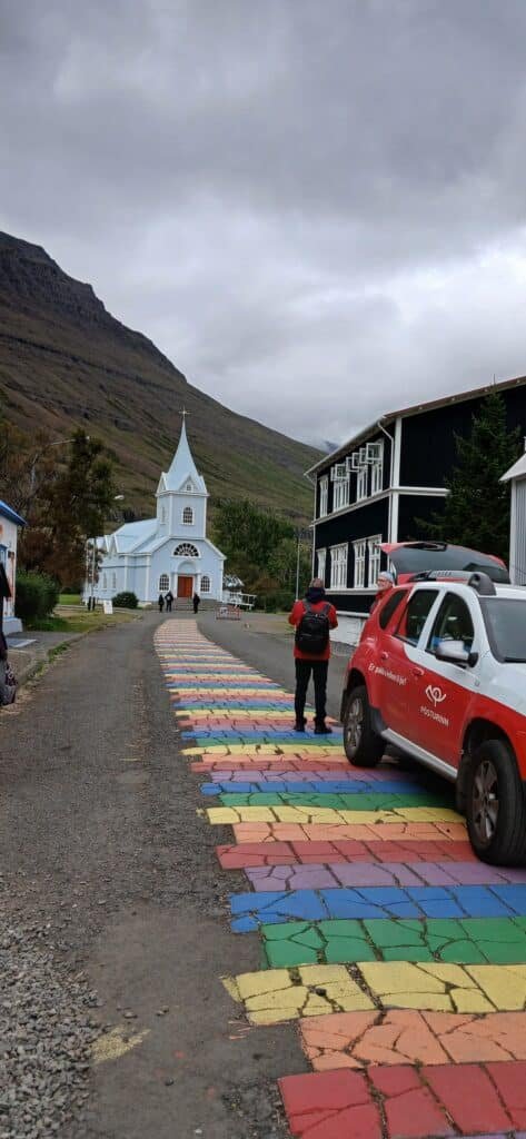
A small town at the end of a dramatic fjord, reached via a winding mountain pass, Seyðisfjörður is known for its colorful Rainbow Street leading to a blue church, its collection of well-preserved wooden buildings, and a genuinely artistic community that feels distinct from anywhere else in Iceland. The town also serves as the country’s only ferry connection to mainland Europe, giving it a modest but steady flow of international visitors quite different from the typical Ring Road tourist crowd.
Seyðisfjörður, East Fjords, via mountain pass from Egilsstaðir. Free to explore. Best combined with the scenic drive over Fjarðarheiði for waterfall stops along the way.

7. Djúpavík
A near-abandoned herring factory village on the remote Strandir coast, Djúpavík offers a genuinely eerie, atmospheric look at a once-booming Icelandic industry that collapsed decades ago, along with a small hotel converted from the old factory workers’ quarters for travelers willing to make the detour.
Djúpavík, Strandir coast (technically Westfjords-adjacent, often paired with East Fjords or Westfjords legs). Free to explore. Best for travelers specifically interested in Iceland’s industrial history.
North Iceland
North Iceland offers some of the country’s most dramatic waterfalls and best whale watching, with a fraction of the South Coast’s crowds.
8. Dettifoss
Widely considered Europe’s most powerful waterfall by volume, Dettifoss delivers a genuinely visceral, thunderous experience that the more delicate, photogenic Gullfoss on the Golden Circle doesn’t quite match, despite Gullfoss capturing the vast majority of “Iceland waterfall” search traffic. The falls sit within Vatnajökull National Park, and the spray thrown up by the sheer volume of water is often visible from a considerable distance before the falls themselves come into view.
North Iceland, off Route 862 or 864. Free. Best combined with a stop at nearby Selfoss, a short walk upstream.
9. Mývatn’s Lesser Lava-Field Trails
Beyond Mývatn’s well-known geothermal baths, the surrounding Dimmuborgir lava field offers a genuinely strange, otherworldly landscape of twisted lava formations, with several less-trafficked trails winding through the rock beyond the main viewing loop. The lake itself, formed by a volcanic eruption thousands of years ago, also supports pseudocraters, unusual volcanic formations created by steam explosions rather than magma, adding another layer of genuinely strange geology to an already unusual area.
Mývatn area, North Iceland. Free. Best combined with a visit to the Mývatn Nature Baths for a soak after hiking.
10. Húsavík
Iceland’s whale-watching capital, Húsavík offers considerably higher sighting rates and a smaller-scale, more personal tour experience than the boat trips departing from Reykjavik, thanks to its position directly on Skjálfandi Bay’s rich feeding grounds.
Húsavík, North Iceland. Free to visit; whale-watching tours priced separately. Best April through August for peak whale activity.
Snæfellsnes Peninsula
Often called “Iceland in miniature” for packing the country’s varied landscapes into one compact peninsula, Snæfellsnes sits close enough to Reykjavik for a shorter trip while still delivering a genuine Ring-Road-caliber experience.
11. Kirkjufell From Different Angles
Iceland’s most photographed mountain typically appears in a single famous composition with the adjacent waterfall Kirkjufellsfoss in the foreground, but walking around the base of the mountain or viewing it from the nearby coastline reveals angles that avoid the crowd clustered at the one iconic photo spot. The mountain’s distinctive, near-symmetrical peak shape, formed by glacial erosion isolating it from the surrounding landscape, is part of why it’s become such a recognizable symbol of Iceland despite its relatively modest 463-meter height.
Near Grundarfjörður, Snæfellsnes. Free. Best at sunrise, both for light and for avoiding the crowds that gather later in the day.
.jpg)
12. Djúpalónssandur
A black-sand beach scattered with rusting shipwreck remains and dramatic rock formations, Djúpalónssandur also holds four historic lifting stones once used to test the strength of prospective fishermen, adding a genuine layer of local history to an already striking landscape.
Djúpalónssandur, Snæfellsnes Peninsula. Free. Best combined with a broader Snæfellsjökull National Park visit.
The Westfjords
Iceland’s least-visited region by a wide margin, requiring a genuine detour off the main Ring Road but rewarding the extra time with some of the emptiest roads in the country.
13. Dynjandi
The Westfjords’ most iconic waterfall, Dynjandi cascades down a series of tiered drops widening as it falls, and despite being one of the most photographed sites in the region, it remains dramatically less crowded than comparable waterfalls elsewhere in Iceland simply due to the Westfjords’ remoteness. The falls are sometimes called Fjallfoss, and the wide, fan-shaped uppermost drop, roughly 100 meters tall, is flanked by five smaller cascades that make the full climb alongside the falls considerably more rewarding than viewing them from the base alone.
Arnarfjörður, Westfjords. Free. Best allowing time to climb partway up alongside the falls for progressively better views.

14. Rauðasandur
A rare stretch of red-and-golden sand beach in a country almost entirely dominated by black volcanic sand, Rauðasandur’s remote location and unusual coloring make it one of the most distinctive beaches in Iceland, seeing only a fraction of the visitors that flock to the South Coast’s black-sand beaches.
Rauðasandur, Westfjords. Free. Best on a clear day when the sand’s unusual coloring shows most vividly.
Ring Road Logistics: How Many Days You Actually Need
The Ring Road itself covers roughly 1,300 kilometers and can technically be driven in 2-3 days without stopping, but that pace defeats the entire purpose of the trip. A realistic itinerary that actually stops for the sights above needs at least 7-10 days for the main loop, and most first-time Ring Road drivers underestimate how much time individual stops consume, particularly waterfalls and viewpoints that require walking beyond the parking area. Adding a genuine Westfjords detour, given the region’s distance from the main route and its slower, more winding mountain roads, extends a realistic trip to 12-14 days.
Direction of travel matters less than most first-time planners assume, though a counter-clockwise route starting toward the South Coast is the more common choice, partly because it front-loads the most famous, most crowded sights early in the trip while energy and enthusiasm are highest, saving the quieter North Iceland and Westfjords legs for later in the journey.
Best Time of Year for the Full Ring Road
Summer, roughly June through August, offers the most reliable driving conditions and full accessibility, including F-roads into the highland interior that close entirely in winter. Winter driving brings the possibility of Northern Lights and dramatically thinner crowds, but also short daylight hours, more limited road access, and genuine risk on exposed, ice-prone stretches, particularly in the Westfjords and East Fjords where mountain passes see the most severe conditions.
Late spring (May) and early autumn (September) offer a reasonable middle ground for travelers who want fewer crowds than peak summer without committing to full winter driving conditions, though some F-roads and remote mountain passes may still be closed or only recently reopened depending on the specific year’s snowmelt.
Practical Driving Tips
Checking road.is, Iceland’s official road conditions site, before setting out each day is essential rather than optional, since conditions can change quickly and closures aren’t always intuitive from a map alone. Gravel roads are common once off the main Ring Road, and driving etiquette matters here: slowing down significantly for oncoming traffic and single-lane bridges (common throughout the country) prevents both damage and dangerous situations. Gas stations thin out considerably in remote stretches, particularly in the Westfjords and parts of the Southeast, so refueling well before the tank runs low, rather than waiting for the next town, is a habit worth building early in the trip.
Wind deserves specific attention that guidebooks sometimes underplay: Iceland’s open landscape means gusts can be strong enough to make opening a car door genuinely difficult or even damage it if not held carefully, and high-profile vehicles like campervans require particular caution on exposed stretches during windy weather. Vedur.is, the Icelandic Meteorological Office’s site, provides wind forecasts alongside standard weather, and checking it alongside road.is gives a fuller picture of what a given day’s drive will actually feel like.
If this guide helped you plan your Iceland road trip, subscribe to Worldly Traveler on YouTube for more hidden gems guides from around the world.
Where to Base Yourself Along the Way
Most Ring Road trips work best as a series of one or two-night stops rather than a single fixed base, given the distances involved. Vík makes a practical South Coast base for reaching Fjaðrárgljúfur, Dyrhólaey, and Reynisfjara without excessive daily driving. Höfn, known locally for its langoustine, works well as a Southeast base near Vatnajökull and Stokksnes. Akureyri, Iceland’s second city, anchors North Iceland nicely, sitting within reasonable driving distance of both Mývatn and Húsavík. For the Westfjords specifically, Ísafjörður functions as the region’s main town and most practical base, though its distance from the rest of the loop means budgeting real time to reach it in the first place. Booking accommodation well in advance for July and August is worth doing regardless of route, since smaller towns along the Ring Road have limited room inventory that fills up quickly during peak season.
Frequently Asked Questions
How long does it take to drive Iceland’s full Ring Road?
The Ring Road itself can technically be driven in 2-3 days without stopping, but a realistic trip that actually sees the sights along the way needs at least 7-10 days, and 10-14 days allows time for genuine detours into the Westfjords or the East Fjords without feeling rushed.
Is a 4×4 necessary to drive the Ring Road?
A standard 2WD car is sufficient for the paved Ring Road itself in summer, but a 4×4 becomes necessary for many of the F-road mountain tracks into the interior highlands, and is strongly recommended for winter driving given ice, snow, and sudden weather changes on exposed stretches of road.
What are the best hidden gems beyond the Golden Circle?
Fjaðrárgljúfur canyon and the quieter side of Reynisfjara on the South Coast, Stokksnes and Vestrahorn in the Southeast, Seyðisfjörður in the East Fjords, Dettifoss and Húsavík in North Iceland, Kirkjufell on Snæfellsnes, and the Westfjords as a whole all reward the extra driving time beyond the standard first-day Golden Circle route.
Is the Westfjords detour worth it?
Yes, for travelers with enough time — the Westfjords is Iceland’s least-visited region despite dramatic fjord scenery, waterfalls like Dynjandi, and genuinely empty roads, though the detour adds several days to a Ring Road itinerary given the region’s distance from the main route and its slower mountain roads.
What is the best time of year for the full Ring Road?
Summer (June through August) offers the most reliable driving conditions and full accessibility to F-roads and remote regions, while winter brings Northern Lights potential and dramatically fewer tourists at the cost of shorter daylight hours, more limited road access, and the need for genuine winter driving experience.
Is it safe to self-drive Iceland’s Ring Road in winter?
Winter self-driving is possible but requires real preparation: checking road.is for current conditions daily, driving a well-equipped vehicle, building in significant schedule flexibility for weather delays, and having genuine experience with ice and snow driving, since conditions can deteriorate quickly on exposed stretches.